This dataset was used for implementation of an ensemble model for sugar cane burning detection in North and Central Coast of Peru. For more information, please visit the project
To download the dataset, run the following command:
git clone https://huggingface.co/datasets/jfloresf/scburning
cd scburning
Revert the multipart compression: merge first, then untar
cat database/database.tar.* | tar -xzvf - -i
cat inference/emergencies/emergencies.tar.* | tar -xzvf - -i
cat inference/pilot/pilot.tar.* | tar -xzvf - -i
Consists in 1,054 images of 512x512 pixels with different
folders:
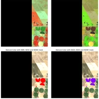
Sentinel-2 10 bands ('S2'), Normalized Burn Ratio ('nbr'), Burned Area Detection Index ('badi'), Slope in percentage ('slope'), Normalized Difference Vegetation Index ('ndvi'), Normalized Difference Water Index ('ndwi'), Distance to Crop Cover ('dlc'), Ground Truth ('target') according the following structure:
database/
├── badi/
│   ├── ROI_0000_01_04__..._20201008T082324.tif
|   ├── ...
├── dlc/
│   ├── ROI_0000_01_04__..._20201008T082324.tif
|   ├── ...
├── landcover/
│   ├── ROI_0000_01_04__..._20201008T082324.tif
|   ├── ...
├── nbr/
│   ├── ROI_0000_01_04__..._20201008T082324.tif
|   ├── ...
├── ndvi/
│   ├── ROI_0000_01_04__..._20201008T082324.tif
|   ├── ...
|── ndwi/
|   ├── ROI_0000_01_04__..._20201008T082324.tif
|   ├── ...
|── slope/
|   ├── ROI_0000_01_04__..._20201008T082324.tif
|   ├── ...
|── S2/
|   ├── ROI_0000_01_04__..._20201008T082324.tif
|   ├── ...
|── target/
|   ├── ROI_0000_01_04__..._20201008T082324.tif
|   ├── ...